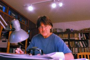
Like many North Shore residents, Denny
Maynard hopes the District of North Vancouver won't wait for another
disaster to happen before it gets involved in protecting the sensitive
residential areas around the Seymour River Escarpment.
Unlike others, Maynard made his opinion known to the District in 1978 when
he completed his Masters thesis on how to incorporate geomorphology into
community planning.
"I was trying to show the impact factors that should be considered,"
Maynard said. "The intent was to show how you could take geological
information as one part of the planning process."
Maynard chose to study the Seymour area because it was known to be fragile
and at that time the development was just getting started. Although some
development of Riverside Drive already existed, Mount Seymour Parkway was
sparse and everything above it was forest, he said.
The District supported his study by providing him with maps and background
information. In return, Maynard offered his findings to them, but they
were never officially incorporated into their planning.
One of the impact factors mentioned in Maynard's thesis was slope
stability. Although he didn't specifically address hazard assessments, he
did indicate how areas prone to slope failure could be identified.
"In the Seymour area most zones of instability are indicated by numerous,
but small failures," the report stated. "In many cases flow of saturated
soil, indicating an excess of groundwater seepage, is the only evidence."
Maynard reported slides and washouts were common along Lynn Creek,
McCartney Creek and the Seymour River.
He found the scarp itself to be unsuitable for development, but points out
there has been relatively no development along it since.
"Unfortunately at that time there were houses already there," he said.
"It's devastating for the people involved in that slide."
A year after his thesis a slide occurred that destroyed a house built at
the bottom of the slope, which triggered geotechnical assessments on the
area. In Maynard's opinion the District's next step should have been to
have site specific tests done on the areas that required more follow up.
"You can't just turn a blind eye," he said. "The engineers who put out the
report did their job, but it's recommendations got lost in the
bureaucracy."
After last Wednesday's slide, friends of Maynard were evacuated from their
home, which was built beside the house on Berkley Avenue that lost its
backyard. He suspects site specific tests are now being performed on his
friend's house and those in the immediate vicinity.
"It seems the District gets interested in these things every time they
happen," he said. "They fix them and then life carries on until the next
disaster."
At Monday's District council meeting, James Ridge, the District's chief
administrator, announced a forensic review of the area was already
underway. Priorities, he said, were monitoring the site and mitigating
further hazards. He said a geotechnical engineer would be hired by the
District for a minimum of two years to look at the area's drainage and
provide a full analysis of the slope. The District also plans to implement
a slope management plan and look at new property regulations.
"We will bring forth an action plan," Ridge said in front of a overflowing
council chamber. "Our priorities are very different now than they were
last week."
Maynard is impressed with how the District is dealing with the aftermath
of last week's slide and is eager to finally see steps taken to ensure
long term stability of the slopes. Regardless of whether the District of
North Vancouver is legally required to do so doesn't matter, he said.
"There's a moral responsibility. Our professional association is bound by
a code of ethics to make the public aware of health and safety issues."